


Summary (English)
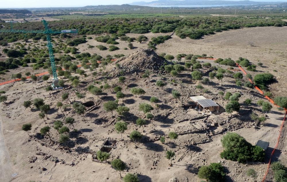
Excavations took place in three different sectors: the area north-east of the fortress with open area excavations in area λ and the complete excavation of room B in the warehouse, and of one of the rooms in block K. In addition, investigation of the nuragic complex itself began, with the aid of a crane.
Area Λ and room B of the warehouse.
Open area excavations were undertaken in Area Λ in order to document its topography. The removal of US 0 revealed several sub-elliptical buildings, including a small complex of two modules with walls that were straight on the long sides and curvilinear on the ends, and a large construction ( λ1) with an entrance preceded by a platform and a paved surface.
Room B (3 × 2.40 m) was situated between the earthworks of the first phase of the fortress. The investigations went down to a floor surface (US 618) in phase with a truncated cone-shaped kiln (USM 620) made of stones and unbaked clay (US 616), of uncertain function and covered by a sequence of two collapses (US 507 and 504). The group in phase with the floor and kiln constitutes the remains of an open area relating to phase I of the fortifications, later incorporated into the fortified warehouse.
Chronology US 618,USM 620: c. 625-575 B.C.BLOCK K
Within block K, comprising two straight-curvilinear spaces, the excavations concentrated on space K2, interpretable as an open-air craft space. In phase with the walls (standing to up to 2 m), a beaten clay surface (US 1027) was exposed that was on different levels due to a system of slopes, channels, pits and vats for the collection and use of rain water. A system of channels was fed by rainwater, which from the entrance passageway was channelled into one of the walls (USM 1012) to exit in the north corner. From here, it was channelled into three vats, in the first of which there was evidence of a stone-slab facing (USR 1037). In the third tank, the water settled before overflowing into a last vat situated in the east corner. The latter’s floor was lined with small slabs and the water flowed out through a small hole in the foundations of USM 1014. A small square kiln, probably a limekiln, was built later over the second vat. (USM 1053, USM 1057).
These features were covered by a first layer of collapse (US 1026) with a very black ashy matrix, the result of a fire that destroyed a wooden pergola and mixed with collapse US 1024, which had a loose yellowish matrix and was present in several patches in US 1026. US1026 contained several fragmented containers (reconstructable), in particular crucibles and cooking pots. The successive layer contained numerous objects of daily use found in situ: slab-shaped “millstones”, grindstones and a large number of collapsed pottery vessels, grouped in the north corner, perhaps originally positioned on shelves: amphorae (at least three, one containing lime), jars, cooking pots, lamps, and dippers. The subsequent collapse of mud brick wall US 1023, on average 80 cm deep and very compact/hard, also contained reconstructable ceramic vessels and lithic implements (primarily sharpeners) concentrated along the south-east side, and which had also fallen to the ground.
Chronology US 1027 and UUSS in phase: c. 625-575 B.C.
SECTOR I, NE QUADRANT OF THE QUADRI-LOBED STRUCTURE
The investigations begun in Sector I in the northern part of the quadric-lobed complex, between the north tower and the one east of the external bastion, involved the removal of US 2000. This was formed by recent collapses of the blocks from the towers and the walls of the bastion nuraghe. A dry-stone wall (USM 2001) was also removed, probably dating to the final years of the 19th century, partially built using blocks from the nuraghe itself.
The first result of this work is the improved legibility of the monument, the tops of the walls of the curtain wall and the towers of the bastion are now more clearly visible.
- Carla Perra - Museo Archeologico Villa Sulcis, Comune di Carbonia
Director
Team
- Roberto Sirigu
- Valentina Ligas - Università di Cagliari
- Maria Antonietta Demurtas
- Andrea Castangia - Società ATI IFRAS s.c. a r.l.
- Antonio Loi - Società ATI IFRAS s.c. a r.l
- Carlo Loi - Società ATI IFRAS s.c. a r.l.
- Danilo Leccis - Società ATI IFRAS s.c. a r.l.
- Franco Tocco - Società ATI IFRAS s.c. a r.l.
- Gianfranco Cardia - Società ATI IFRAS s.c. a r.l.
- Giuseppe Masala - Società ATI IFRAS s.c. a r.l.
- Mariuccia Monni - Società ATI IFRAS s.c. a r.l.
- Matteo Lobina - Società ATI IFRAS s.c. a r.l.
- Roberto Cubeddu - Società ATI IFRAS s.c. a r.l.
- Roberto Pititu - Società ATI IFRAS s.c. a r.l.
- Roberto Zuddas - Società ATI IFRAS s.c. a r.l.
- Rosanna Masala - Società ATI IFRAS s.c. a r.l.
- Salvatore Corriga - Società ATI IFRAS s.c. a r.l.
- Salvatore Sanna- Società ATI IFRAS s.c. a r.l.
- Stefano Di Crosta - Società ATI IFRAS s.c. a r.l.
Research Body
- Museo Archeologico Villa Sulcis
Funding Body
- ATI Ifras s.c. a r.l
- Comune di Carbonia
- Provincia di Carbonia Iglesias

![[PDF]](download.php?file=2572.jpg "Download")
![[PDF]](download.php?file=2573.jpg "Download")