


Summary (English)
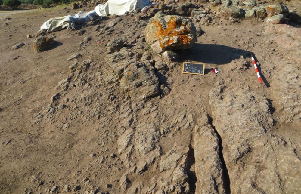
Excavations took place in an area situated at the foot of the village fortifications, north of the second fortified line. The removal of the humus (US0) in the zone closest to the fortifications revealed a series of small channels running south-north created by emphasising the natural fractures in the rock (probably using a chisel, -US709).
At about 10 m from the fortifications, two parallel cuts (-US710), about 1 m apart and perpendicular to the channels, delimit a larger channel and interrupt the system, directing a substantial part of the rainwater flow to the east. Further north, where the rock takes on the appearance of a high irregular outcrop, fragmented by natural fissures orientated north-south, the system took on a different appearance: a dense network of channels with perfectly cut vertical walls (-US712), in some parts rather deep (up to 40 cm), orientated north in continuity with those situated to the south. This network also included small transverse channels, often oblique, which when necessary probably diverted the water towards the east, downhill, where collecting basins may be present, or even a moat that could surround the lower part of the hill.
As regards the stratigraphy, between the humus and the bedrock, intermediate surfaces formed by more compact soil were found at several points, in some cases (UUS 700, 702,US 705, 706) interpretable as artificial dumps in pressed earth and cobbles used to level the surfaces in which the channels ran. Continuing in the main direction of the channels (north), in correspondence with a high rocky outcrop, several collecting vats were uncovered. One of them had a sub-circular perimeter (-US714) whose surface had been evened using round-pointed chisels, as attested by the repeated marks visible on the rock surface.Based on the physical and stratigraphic relationships between the deposits and the excavated structures, the system of channels seemed to indicate a correlation with the stratigraphic contexts relating to the second line of defences (575-560/550 B.C.). However, given the lack of a secure dating for the levelling deposits it cannot be excluded that the water collection system predates the entire fortification system and that the latter was adapted to a pre-existing structure.
As regards function, it is suggested that this was a system for rainwater collection. Given its capillary ramifications, it could have different destinations: part of it could terminate in collecting basins at an upper level, for various uses, thanks to a long decantation course; in part, according to need, it could flow into cisterns or even to a possible moat or channel associated with agricultural activity. The presence of cuts and small perpendicular channels running east could also be explained by the possibility of needing to divert the water from its main course to avoid “overflow”.
- Carla Perra – Comune di Carbonia, Museo Archeologico Villa Sulcis
Director
- Carla Perra – Comune di Carbonia, Museo Archeologico Villa Sulcis
Team
- M. Giovanna Sulas-Fondazione Cammino Minerario di Santa Barbara
- Mafalda Mascia-Fondazione Cammino Minerario di santa Barbara.
- Maristella Cera-Fondazione Cammino Minerario di Santa Barbara
- Luca Zambianchi e Roberto Mura-Fondazione Cammino Minerario di Santa Barbara
- Rosa Anna Masala, Roberto Zuddas, Antonio Loddo, Giuseppe Masala, Luigi Puddu, M.Giovanna Sulas. (Fondazione Cammino Minerario di Santa Barbara)
Research Body
- Museo Archeologico Villa Sulcis
Funding Body
- Comune di Carbonia
- Fondazione CMSB
![[PDF]](download.php?file=7235.jpg "Download")
![[PDF]](download.php?file=7236.jpg "Download")