


Summary (English)
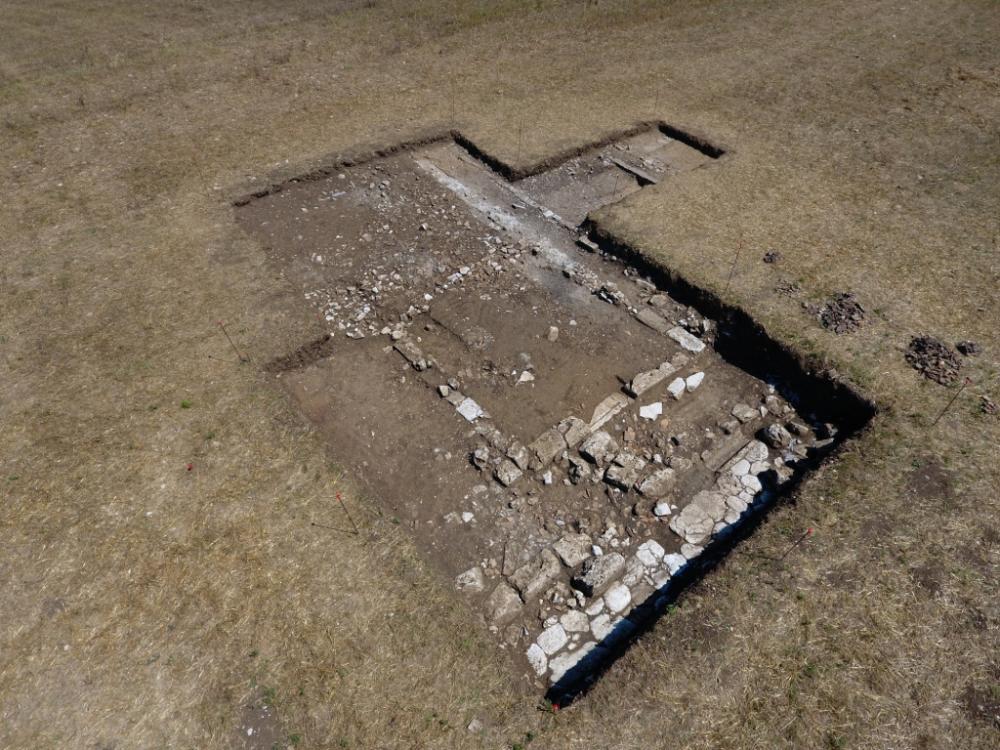
The excavations uncovered the block-built Building A, identified in 2015, and clarified the relationship between the structure and the urban via glareata running north-south (documented using photo-interpretation), and explored the area east of this road, where the traces on the aerial photo suggested the presence of another large structure.
The 2015 trench was reopened and extended to the north, re-exposing the southern front of Building A and the stretch of basalt road on an east-west alignment; a 4 × 7 m trench was opened to the east.
The extension of the trench identified: the northwards continuation of the east wall (USM 148), the partition wall USM 178 (that had collapsed to the south) on an east-west alignment that divided the building into two rooms and abutted the east wall USM 148, the block-built western kerb (USM 174) of the via glareata running to the east of Building A. The removal of the humus revealed a layer, which covered both Building A to the north of partition wall USM 178, and the structure’s eastern wall. The substantial depth of layer US 175 in the western part of the trench made it impossible to identify the northern continuation of the west wall (USM 149), only visible for about 5 m. The east side (USM 148 of which the caementicium foundation, c. 0.60 m wide, evenly razed) was identified to a length of 12.50 m. However, the trace on the aerial photograph and the collapsed elements in trench 2 of 2015, made it possible to suggest that Building A was c. 14 m long.Building A, orientated c. 13° west, on the same alignment as the ancient city’s urban plan, was constructed on a area sloping slightly to the south; therefore, the block-built wall was better-preserved on the south side (USM 147), 6.20 m long with a 1.55 m opening and a limestone threshold. It may be suggested that there was a continuous cement foundation, created in steps to allow the positioning of the block on a horizontal surface.
The opening of the trench to the east, in correspondence with the stretch of kerb US 174, revealed the north-south via glareata and two walls in ¬_caementicium_ and blocks (USM 185 and 186) relating to a second structure (Building B), on the same alignment as the urban layout. The road was 3.90 m wide, the east kerb 0.90 m wide and the west kerb 1.10m. In this stretch, the total width of the road including the sidewalks was 5.90 m. The eastern sidewalk was 10 cm higher than the western one, thus determining a slight slope to the west of the road surface. Several patches of the road surface were found; a deepening of the excavation along the east sidewalk, where the paving was not preserved, revealed the presence of the make up of pressed clayey sand (US 195).
- Adriana Valchera - Università del Salento, Dipartimento di Beni Culturali, Laboratorio di Topografia Antica e Fotogrammetria (LabTAF)
Director
Team
- Antonio Leopardi - Università del Salento
Research Body
- Università del Salento, Dipartimento di Beni Culturali, Laboratorio di Topografia Antica e Fotogrammetria (LabTAF)
Funding Body
- Comune di San Giovanni Incarico
- Università del Salento, Dipartimento di Beni Culturali
![[PDF]](download.php?file=4358.jpg "Download")