


Summary (English)
The first excavation campaign at the abandoned village of Bisarcio took place from the 10th September to the10th October 2012 and was a collaboration between Sassari University, the municipality of Ozieri, the Archaeological Superintendency of Sassari and Nuoro and the Società Oben.
In the geography of medieval Sardinia, Bisarcio, Episcopal seat of the diocese of the same name, is situated in the north-eastern part of the Giudicato of Torres. It stands along the main road between Porto Torres, Sassari and the link to the road for Cagliari, in line with the bordering dioceses of Ploaghe (to the west) and Castra (to the north-east), and in a zone not far from the border with the Giudicato of Gallura.
Bisarcio is of particular significance for medieval Sardinia as it was the seat of the diocese from the 1080s until the 16th century, and an important village, capital of the medieval curatoria of the same name.
At the end of the 1500s, Giovanni Francesco Fara described the village as almost destroyed, with a few huts “that preserved nothing of the grandeur of the ancient buildings” while in the _ Relazione sugli stati di Oliva_ written in 1769 by Vincenzo Mameli De Ormedilla the village resulted as having not long been destroyed, with some houses almost intact.
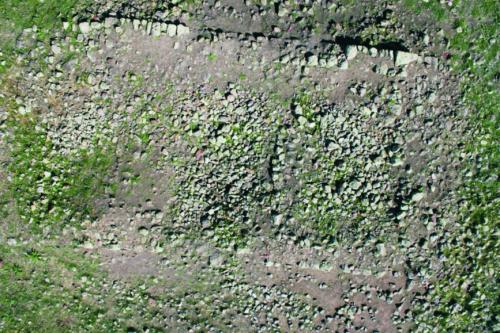
The archaeological interventions concentrated on the Episcopal complex, represented by the basilica of Sant’Antioco di Bisarcio and related structures, and on the area interpreted as a village. In the area around the basilica, two excavation areas were opened, the first (area 5100) was a 10 × 10m square, dug with the aim of assessing the quality of the archaeological deposits present in the immediate vicinity of the basilica. The second intervention was the opening of a rectangular trench (area 5300) dug in order to find out how the slope, on the summit of which the basilica stands, was formed.
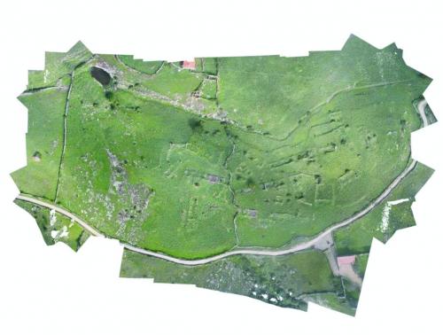
The area identified as the site of the remains of the village of Bisarcio, is uncultivated, characterised by piles of stones and an uneven surface due to the outcropping of the structures below.
The most visible traces of the village are situated north of the church, but it cannot be excluded that in the past it also extended to the east, where today there are numerous modern buildings. When the work began, ruins of various dimensions, their perimeter walls visible, were present north of the church. The best-preserved buildings were the church of Santa Croce, whose apse was clearly visible, and the remains of a large structure presumably high status private property or public building, as it was much larger than the others were, and had more than one storey.
A high-density survey identified the remains of over 120 buildings. They were recorded and a plan of the village was created that gave an understanding of the urban planning, the roads, the rows of houses, private and public spaces, the probable cemetery, and the relationship with the Episcopal complex.
Following this complex phase of topographical investigation and recording, during which a drone owned by the Società Oben was used, two excavation areas were chosen. They correspond with two separate buildings (areas 100 and 300), whose stratigraphic excavation aims to define the formation processes, determined by the dynamics of the abandonment, collapse and robbing of the village.
Already in the superficial layers, the excavations showed the presence of proto-historic (Iron Age I) and Roman pottery. It is not to be excluded that the geophysical survey picked up structures dating to these periods.
Finds from the site of Bisarcio are present in the Archaeological Museum of Ozieri and clearly attest the long settlement history on this site.
However, there are no details as to how or where they were found, the generic toponym “Bisarcio” is given as the find site. In the 2012 trenches, materials were recovered that although in secondary deposition constitute the first elements on which to base the division of the site into periods, with finds from the early Iron Age, the late Hellenistic, Roman, medieval and post-medieval periods.
- Marco Milanese - Università degli Studi di Sassari
Director
Team
- Angela Antona - Soprintendenza per i Beni Archeologici delle Province di Sassari e Nuoro
- Annarita Becciu
- Antonella Bonetto
- Antonella Deias
- Manuela Simbula
- Martina Zipoli
- Matteo Pipia
- Alessandra Deiana
- Carla Sgarella
- Giovanni Frau
- Maria Cherchi
- Maria Chiara Deriu
- Paola Derudas
![[PDF]](download.php?file=278.jpg "Download")
![[PDF]](download.php?file=279.jpg "Download")