


Summary (English)
This season, Amsterdam University continued its archaeological research in the urban area of ancient Satricum. Work took place on the land belonging to the Casale del Giglio, zone of Poggio dei Cavallari II (PdC II) (Cadastral sheeet no. 6, Comune di Latina, lots 83 and 85).
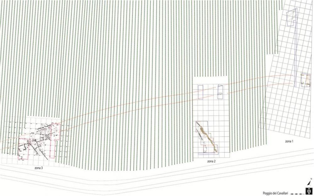
The principal aim was to make an in depth examination of the ancient structures belonging to the so-called “via sacra”, and of the already identified buildings there, and to check for the presence of other ancient structures in the excavation area.The investigations concentrated in two areas, zones 2 and 3 (Fig. 1). Here, a number of trenches, only partially excavated previously, were reopened and enlarged (see Fig. 1: 2016 excavation edges indicated in red).
In zone 2, research concentrated on three trenches in the southern part that were partially excavated in 2004 and 2005 when a number of walls were identified. These have been attributed to a side branch of the main road that crossed the city from east to west. The excavation area was extended to the west, east, and south. The eastern containing wall of the side road was followed to the south. Several sections of wall were discovered at the far southern end, where the wall seemed to terminate with a large block placed short side on. They were made of rectangular blocks of lithoid tufa, forming slightly curved and parallel rows at different levels and sloping heavily to the west to a depth of c. 1.50 m below the level of the modern trench. The terrain was very uneven in this area. For the moment, it is not clear whether the blocks were in their original position or had slipped to a lower level.
A substantial layer of tufa present in almost the entire trench at a depth of c. 1.60 m was uncovered in the south-eastern corner of the excavation and continued towards the south and east in the trench sections. In the western part of the trench, also along the south side, a compact layer of tiles and imbrices was identified. This was probably an in situ roof collapse as suggested by the presence of concentrations of cobblestones below the tiles that seemed to be part of a floor surface. In some places, where tile fragments were removed, large fragments of coarse ware pottery lay on the cobblestones. Among the recognisable forms were a large bowl and a large basin. A small trench opened on the eastern edge of the tile layer revealed two blocks of lithoid tufa belonging to a new wall that seemed to run north-west/south-east. This could be the structure’s exterior wall. Further excavations in this area are necessary in order to investigate in detail the structure with the tile roof and to link the various features.In zone 3, the westernmost area excavated on the Poggio dei Cavallari, previous investigations years had uncovered the continuation of the main road, in addition to the substantial architectural remains of two large buildings (A and B) along the south side of the road, divided by a side road. In depth excavations took place in building B. In one of the trenches on the north side of the building’s north wall, sterile was finally reached at c. 2.90 m below modern ground level. This is the deepest level in the area and shows the natural difference in height from south to north that was used for the construction of Satricum’s main road, which crossed zone 3 on a diagonal line (see Fig. 1, the dotted red lines indicate its line below the vines).
The lowest point of the road trench had already been uncovered in several points previously. However, in contrast with the known stratigraphy underneath the road surface, which consisted of an artificial fill of clay, the lower layer in the trench was made up of numerous pieces of rubble including large pieces of baked clay showing the impressions of construction elements such as timber posts, branches, and canes. This rubble may relate to the occupation pre-dating the construction of the archaic walls, possible in the Iron Age, or to later activities associated with a first house-building phase. An interesting theory is to associate the rubble with the small and large postholes found in the natural, uncovered during the 2015 excavations in the adjacent trench, inside the building, and interpreted as evidence of occupation pre-dating the archaic walls. This year, further cleaning of the level with the postholes made these traces even clearer.In 2015, a layer of cobblestones was identified that extended along all of the western side of the excavation area. The layer also covered the remains of archaic walls including the north wall of building B. North of this wall the layer continued and gradually sloped down to the surface of the main road. Although badly disturbed by modern ploughing, this layer has been interpreted as a floor surface. Based on the later white, orange, and pink tile fragments found among the cobblestones, the surface has been dated to the middle Republican period when a Roman colony was established at Satricum.
Several trenches opened in the cobblestone layer on the north side of the wall showed that the cobbles lay on a thick layer of sterile sand that in turn covered a layer of red archaic tiles. In the last trench dug this season, the tiles rested on a layer of large dolia fragments, which like the tiles seemed to have been intentionally placed in this position to act as drainage for the sandy layer above.
- Marijke Gnade - AAC-Università di Amsterdam
Director
Team
- Martina Revello Lami - Università di Amsterdam, AAC
- Desiré Steures - Università di Leiden
- Ivan Kisjes – Università di Amsterdam
- Loes Opgenhaffen - Università di Amsterdam, AAC
Research Body
- Università di Amsterdam, ACASA
Funding Body
- Azienda agricola ‘Casale del Giglio’
![[PDF]](download.php?file=4334.jpg "Download")