


Summary (English)
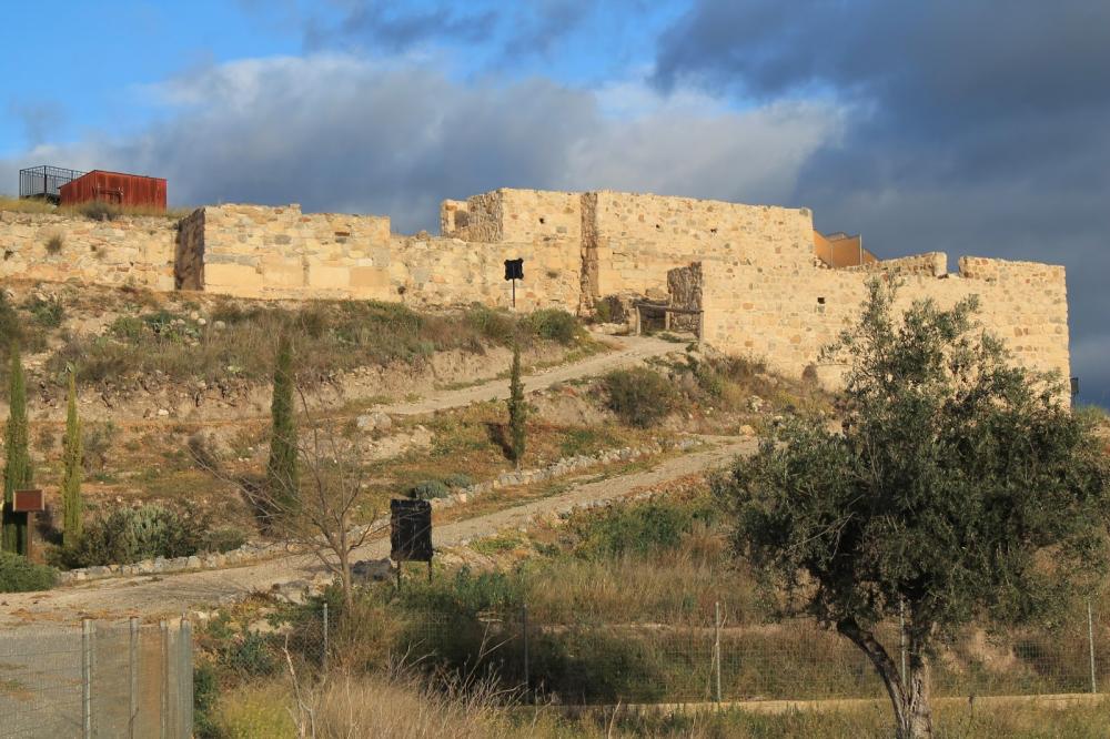
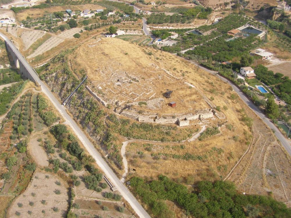
The hill where is located the city of Begastri is very close to the Quipar riverbed, in the northwest sector of the region of Murcia. The archaeological site is in the hill of Cabecico Roenas, about 2,5 kilometres north of Cehegín and it covers an area of more than 2 hectares.
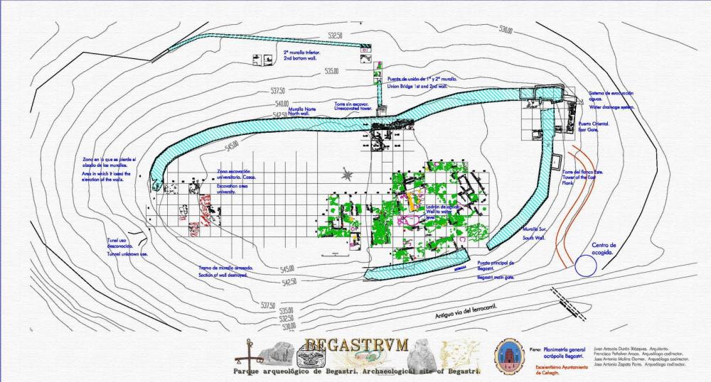
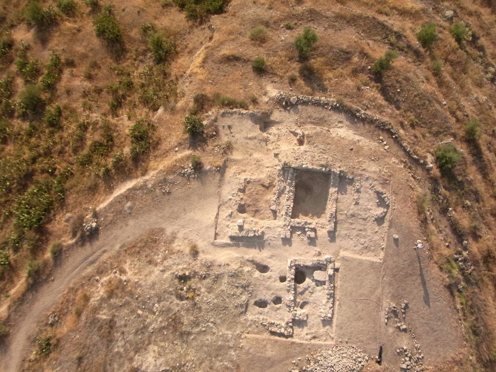
The existence of important archaeological remains has been known since the mid-17st century. In 1878, A. Fernández Guerra located Begastri based on the epigraphic documents in the vicinity of Cehegín, whose municipal council town purchased the area in 1985 and declared it a Historic-Artistic Site. In 2002 it was registered as a Heritage of Cultural Interest (“BIC”). The excavations begun in 1980 under the leadership of A. González Blanco, at the helm until 2010. Currently there are excavation and reconstruction works on part of the walls and other areas of the town. Although initially works were aimed at finding the Visigothic town, an occupational sequence from Iberian Age going through Roman Age to the Medieval has been demonstrated. From the very beginning the intention was to capture the main constructional outlines of the town: establish its perimeter, identify its entrances and document the walls. The starting point was established in the lower part of the northern side of the hill where a necropolis was found. However the archaeological excavations have been determined by the walls of the acropolis.
The the main evidence for the Iberian site, which began in the 4th century BC, is ceramic materials and a cyclopean wall that can be seen in certain areas under the one built one in the Late Antique period. In the Roman Republican period there was little change in the settlement. Begastri became a Roman municipium in the 1st century AD and developed into a classic town equipped with public buildings (forum, amphitheatre, temples, shrines, gymnasia and baths_); the discovery of decontextualized capitals, cornices and mouldings, reused in latest dates, corresponds to that time.
In the 3rd century AD the town attained great splendour having then an impressive fortification that is a spectacular example among the Late Antique Hispanic fortified towns. The hill was defined as an acropolis with oval shape measuring 50 meters wide and 150 meters long. Architectural and epigraphic materials from the Roman Early-Imperial buildings were used in order to build the wall surrounding the acropolis.
The Visigothic Age is the best known period of this town, due to the material finds and the written documentation. This urban centre became an episcopal see, countersigned by several Toledan councils. However the bishopric didn’t give it a vital importance nor a noted role; Orihuela, though it never had a bishopric, became the provincial capital and an important Visigothic administrative centre. Begastri kept its population until the 11th century AD, when it was transferred to the present historic centre of the nearby Cehegín, probably because of the pressure of the Arabs who lived there.
By the 4th century or perhaps a little later the walled zone was increased; at present it partially encloses partially the hill slopes within the fortified enclosure known as a “second ring walls”. The existence of subsequent remains of wall to expand the defended area is likely. Whilst some researchers place Begastri in the area held by the Byzantines, this town shouldn’t have been conquered, or at most it could have been under Byzantine domination gor a short period. Future excavations will clarify this matter. The later Muslim occupation didn’t allow the repair of the doors and towers that fortified the town due to strategic reasons. Then the new Cehegín became the main population centre.
(translation by Pilar Alarcón Blázquez)
- José Antonio Molina Gómez
Director
- José Antonio Molina Gómez (Universidad de Murcia)
Team
- José Antonio Zapata Parra; Francisco Peñalver Aroca; José Javier Martínez García
- José Antonio Molina Gómez (Universidad de Murcia)
Research Body
- Universidad de Murcia, Centro de Estudios del Próximo Oriente y la Antigüedad Tardía (CEPOAT)
Funding Body
- Ayuntamiento de Cehegín
- Universidad de Murcia
![[PDF]](download.php?file=3491.jpg "Download")
![[PDF]](download.php?file=3492.jpg "Download")
![[PDF]](download.php?file=3493.jpg "Download")
![[PDF]](download.php?file=3494.jpg "Download")