


Summary (English)
The archaeological excavation at the prehistoric site of Abrigo de la Cantera or Cueva de la Barriada was promoted by the City of Benidorm and funded by the ADENDIA Foundation, under a collaboration agreement signed by both entities. The peculiarity of the site in the archaeological context of the Marina Baixa and its degree of deterioration due to the continued plundering of hikers and clandestine people, advised a rapid intervention.
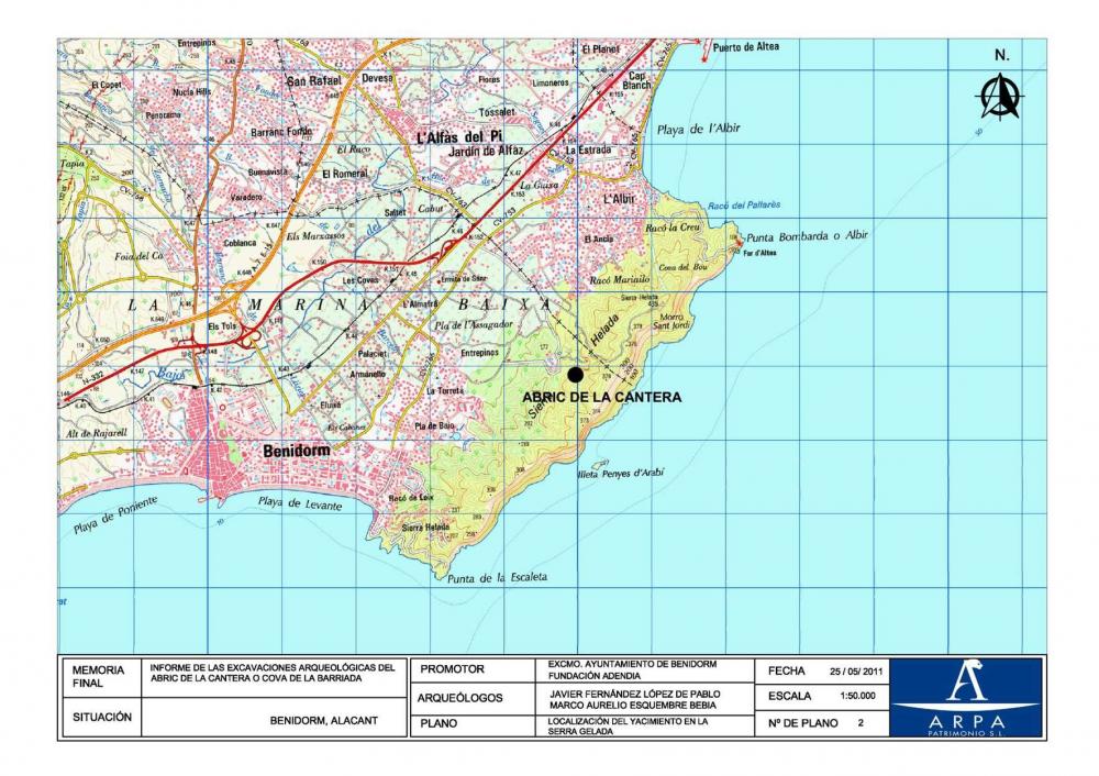
The site occupies the bed of a small ravine that commenced in the western slope of the Sierra Helada, bordered to the North by the quarry and on the west by a sewage farm. In fact, it is a complex of rock-shelters juxtaposed along 60, whose floor describes a form of “V”. Its origin is related to processes of differential erosion and karst dissolution of cretaceous limestones of Sierra Helada. The site can be divided into two different sectors:
- A covered lower unit: south oriented, occupies the right side of the ravine, approximately 20 m long and 6 m wide. There is a masonry wall from the 19th century, which bordered a yard that was in use until recently.
- A covered upper unit: oriented to the west, where the rock wall shelter reaches a higher depth. From the surface earth removals and archaeological materials (lithic industry, remains of terrestrial malacofauna and fauna) are visible. The walls of the shelter conserve traces of the original stratigraphic deposit. In the southernmost part of this unit there is a sedimentary deposition with archaeological materials extremely affected by the actions of plunderers.
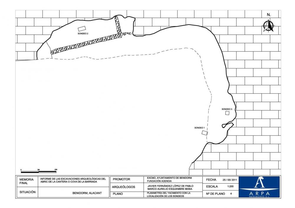
In this intervention, three surveys were conducted. These revealed the space delimitation of areas with archaeological potential and the archaeo-sedimentary sequence of the site.
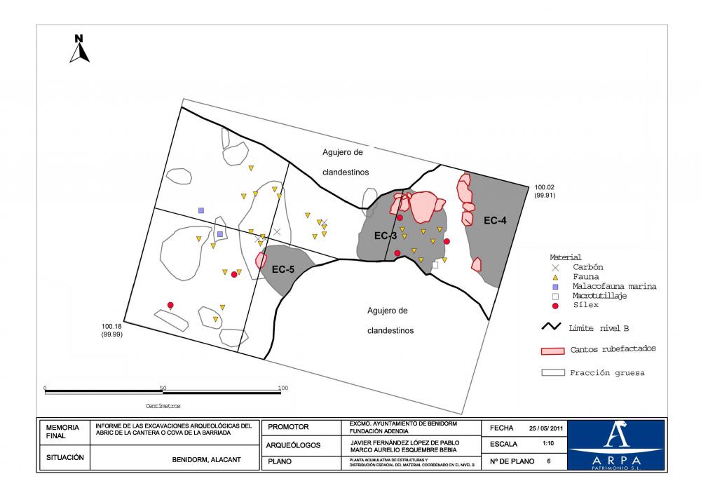
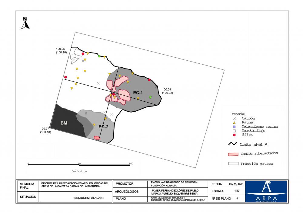
The objective of the Survey 1, located in the upper slope of the coat, measuring 1.5 × 1 m and 2 m deep, was to conduct two stratigraphy profiles along the most damaged area due to the previous clandestine pits. The sequence of occupation documented reflects a succession of three different archaeological levels (A, B and C) containing the remains of a total of 7 homes. The most detailed sequence of the site has been registered here. The evidence of occupation (homes, lithic materials, fauna and malacofauna) presents a clear spatial association defining primary depositional contexts of anthropogenic origin. The absolute chronology situates these levels in the regional Gravetian (v. 25000-22000 BP).
Trench 2, of 2 m2 and 1 m deep, was made in the lower shelter, so-called ‘yard’; its sedimentary deposition has been profoundly altered by the recent stabling, burning and disposal of manure. In the bottom part of the sequence a stratigraphic unit (EU 22) with two small concentrations of charred remains of marine ( Cardium edule and Patella sp.) and terrestrial molluscs ( Sphincterochila candidissima), whose origin is anthropogenic, was documented. The total absence of pottery or carved lithic industry makes the dating of this unit complicated, although we believe that it corresponds to the Holocene.
Trench 3 was inside of the upper shelter, 1 m2 and 1 m deep. Here remains of fauna, malacofauna and lithic industry were documented. It seems that what has prevailed is the process of dissolution which eliminated the sedimentary reservoir in the inside of the shelter.
For the assessment of the current condition of the site we have developed a microtopographic plan of the upper shelter starting from the geostatistic interpolation of the levels taken with total station. The results demonstrate the loss of the archaeo sedimentary reservoir in over 60% of the surface of the shelter. In the southern half of it, the archaeological levels appear directly above the surface, with a high risk of destruction. Therefore, the final report recommends the closure of the site to ensure its preservation.
(translation by Ángel Yeray Rivera Melián)
- Javier Fernández López de Pablo
Director
- Javier Fernández López de Pablo y Marco Aurelio Esquembre Bebia (ARPA Patrimonio, S.L.)
Team
- Antonio Martínez Castelló y Samuel Serrano Salar
Research Body
- ARPA Patrimonio, S.L.
- Colegio Oficial de Doctores y Licenciados en Filosofía y Letras y en Ciencias de Alicante - Sección de Arqueología
Funding Body
- Excmo. Ayuntamiento de Benidorm – Fundación ADENDIA
![[PDF]](download.php?file=4141.jpg "Download")
![[PDF]](download.php?file=4142.jpg "Download")
![[PDF]](download.php?file=4143.jpg "Download")
![[PDF]](download.php?file=4144.jpg "Download")