Summary (English)
The archaeological works regarding this project were contemplated with two purposes: on the one hand, gathering information about the construction of La Plaza de Santo Domingo, in Mérida; and, on the other hand, to confirm or dismiss the layout of the wall and of a possible medieval trench in the medina. So far, this public area had never been excavated using archaeological criteria. We expected to find a domestic environment from the Roman and Late Roman period. However, we intended to clarify any uncertainties regarding the medieval past such as the following: when was this public area formed? Would there be any evidence of the medieval wall and its trench? Which would be the density of the subsoil in this area?
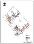
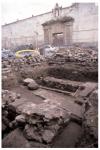
The trench was executed in front of the Santo Domingo convent’s façade in a straight line from the Caja de Ahorros de Badajoz building. We had been informed that a large section of what could be an evidence of the layout of the medieval trench would appear in that area.
This point of the city has always been located within the walls of the city, even during the late Islamic period. The area of the trench covered around 30 m2, and a sum of 33 stratigraphic units were recorded. The trench was excavated to bedrock, 1.70 metres below the contemporary ground level. The domestic structures documented belong to the Roman and Islamic periods. There is a significant lack of room structures from the 13th century to the present day, which seems to date the building and existence of the mentioned “plazuela”.
When the pavement (Stratigraphic Unit 0) was removed, a flooring level made of rectangular granite cobblestones over a mortar and concrete bed was found. Underneath this layer, we detected several ditches related to water and telephone line connections. Such connections had notably divided the stratigraphy, leaving unaltered small portions of land.
In the northern area, a cobbled surface made of river boulders (SU 6) revealed the traffic level of the modern area, although the pavement was lost to a large extent because of the cuts made for the connections. Under the remaining pavement there was a level (SU 8) 35 cm thick over a compact surface of clay (SU 5), which corresponded to the first level of traffic on this outdoors space. At this ground level appeared some stone belonging to walls, but there were no signs of the expected trench. There were no levelling fills. However, under the ground level of the Medieval Christian square, several walls and a uniform stratum (SU 16) were found. The latter was made of soil from the collapse of the rammed earth and of adobe and curved roof tile fragments. This stratum covered the floor of clay to the height of the walls conserved –around 70 cm – of three rooms. The substantial presence of large stones reveals that the structures were ruined without becoming a quarry.
Upon removing the collapsed level (SU 16), small sherds that may belong to the moment the building was abandoned was found. A total of 58 sherds was recovered. Each one of them had a different shape, but a great part was glazed and dated from the 13th century. A cross-shaped marble piece from the Late Roman period was also recovered. It could have been part of a chancel screen or a latticework, and it was probably reused at the medieval wall.
The walls (SUs 15 and 22) preserved part of the masonry elevation connected to the floor on which the rammed earth found in the collapse was erected. The wall of the SU 15 is made of blocks of stone, quartzite and brick fragments; while the other wall (SU 22) was made of smaller blocks of stone and small stones. The latter stands over another wall of mortar (SU 10), whose manufacture and thickness dates to the Roman Empire. The medieval wall (SU 15) is perpendicularly placed next to the thick Roman wall (SU 10) adjoining with two others of the same structure, which consisted of interlaced blocks of stone (SUs 20 and 21). These were still used during the middle ages. Altogether, there is part of a Roman building (A 6) with two rooms whose structure was used until the 13th century. Within the limits of the trench, we are not aware if the rooms within these walls belonged to a single Islamic house or to several of them. The pavement of the rooms is made of compact clay, it has no residual ashes, kitchens or hearth; nor signs of fire on the walls that could reveal the existence of previous kitchens.
The excavation was covered with a layer of sand, which indicates the depth reached during the intervention. Over this layer, soil from the cut itself was cast.
(translation by Susana da Purificação Márquez)
- Miguel Alba Calzado
Director
- Miguel Alba Calzado (Consorcio Ciudad Monumental de Mérida)
Team
- Valentín Mateos
- Javier Pacheco
- Manuel Sánchez Benítez (operario especializado del Consorcio)
- Tomás Molina, Agustín Molina (empresa Vaysaca)
Research Body
- Consorcio Ciudad Monumental de Mérida
Funding Body
- Ayuntamiento de Mérida
- empresa adjudicataria, VAYSACA


![Download [PDF]](/excavation/skins/fasti/images/results/download_sml.png)


