


Summary (English)
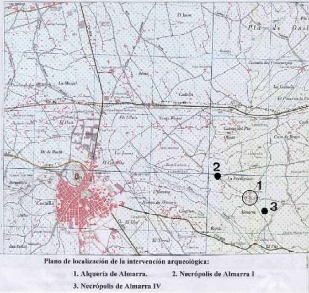
The archaeological intervention carried out on the occasion of the construction of the Alicante-Villena-Alcoy highway was focused on two main points of the line: Almarra I and Almarra IV. In both of them, we proceeded to excavate the archaeological contexts conserved there. In other two points of the line, Almarra II and III, an inspection and a monitoring of the works were also made because of the risk of a possible appearance of archaeological contexts, which was not confirmed at the end. These points are separated from one another by hundreds of meters. However, due to the fact that they are all included in the consignment of Almarra, they were referred to as consecutive Latin numeration, according to the order of intervention.
The archaeological intervention has allowed us to confirm the existence of a rural Islamic population within the village of Foia de Castalla. This population, although assumed, had not been documented until now. That rural population was organized around the farmhouse, as a minimal unity of territorial exploitation, something common to the whole Sharq al-Andalus geography. In the case of the farmhouse of Almarra, the territory would comprise part of the fertile soils, either dry land or irrigated, from the bottom of the geographic basin of Foia de Castalla. This rural area must have been shared by other populations.
The location of the farmhouse does not exactly correspond to the current village. Dated from the 12th and 13th centuries, it was probably abandoned during the Reconquista, to which two necropolis are assigned. The first one is Almarra I, located 750 m north-west from the current village, where the road from Castalla to Ibi forks towards the exit of l’Alfás. The other one, Almarra IV, is located 250 m south-east from the current village. We do not know whether they were used simultaneously, or which of them was prior or subsequent.
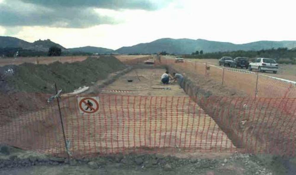
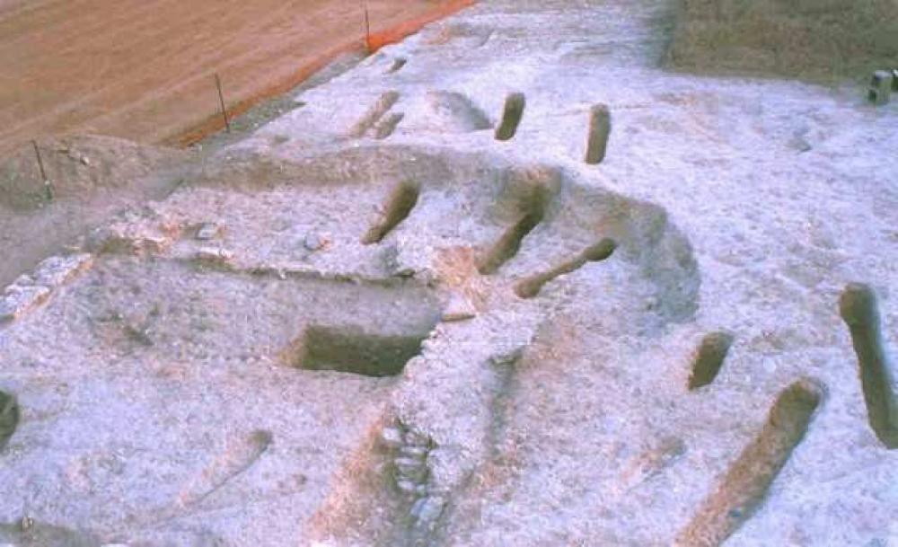
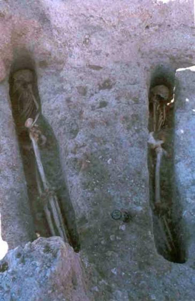
- Almarra I: the excavation of a ditch to put a pipe that supplied potable water to houses and contiguous rural properties exposed a series of burials next to the old road from Castalla to Ibi. The excavation of an extension of 320 m2 has allowed the documentation of part of a Muslim cemetery dated from the 12th and 13th centuries. In the necropolis, with an extension of 3,720 m2, a total of 44 graves with 39 buried people was recorded.
- Almarra IV: the excavation of the main area of the fork in the highway between Castalla and Ibi, at the level of the current communication hub to Villena, exposed a second group of burials. Once the discovery was notified to the works’ management, we proceeded to the excavation. The archaeological remainders were only concentrated in an area of 110 m2 of the 655 m2 open to the excavation in extension of the necropolis. Another Islamic-Andalusian necropolis, dated from the 12th and 13th centuries, was documented. This cemetery had 19 individual burials in trenches.
The burials do not differ in any aspect from the ones excavated in the necropolis of Almarra I. The typology of the trenches, their dimensions, the burial rites, burial positions, etc. systematically repeat the patterns of those from Almarra IV.
Our knowledge about the necropolis of Almarra does not imply a substantial change in the landscape of the Almohad burial world (12th and 13th centuries). This is because it does not differ from other similar rural cemeteries, nor from the great urban necropolis in Valencia and Murcia. However, the verification of a farmhouse means a valuable datum of importance for the county and the region to interpret and explain the rural Muslim population in Foia de Castalla at the end of Islamic rule and before the conquest of this land by King James I of Aragon.
(translation by Susana da Purificação Márquez)
- Gabriel Segura Herrero
Director
- Gabriel Segura Herrero
Team
- MARQ, Museo Arqueológico Provincial de Alicante
Research Body
- Colegio Oficial de Doctores y Licenciados en Filosofía y Letras y en Ciencias de Alicante - Sección de Arqueología
Funding Body
- Ministerio de Fomento
![[PDF]](download.php?file=6059.jpg "Download")
![[PDF]](download.php?file=6060.jpg "Download")
![[PDF]](download.php?file=6061.jpg "Download")
![[PDF]](download.php?file=6062.jpg "Download")