Summary (English)
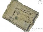
This was the second season of Bologna University’s excavations at the castle of Zagonara. The investigation concentrated on three sectors (1000, 3000 and 4000), situated in the north-western part of the settlement, in the area already investigated in 2017. In total c. 1150 m2 have been excavated.
Sector 1000 was opened in 2017 revealing the foundations of the perimeter walls of a single-nave church, datable to at least the 11th century and identified with the remains of the rural chapel of S. Andrea di Zagonara. The 2018 campaign, documented two successive phases of enlargement and modification of the architectural complex probably from the 13th century onwards. First, around the 13th century, the complex went from having one nave to having a central nave and two lateral aisles, perhaps keeping only the apse from the previous phase. Lastly, between the 14th and early 15th centuries, three lateral chapels were added to the north aisle.
Sector 3000 was opened in correspondence with a zone where a series of anomalies were recorded by a magnetometer survey. The excavations in this sector exposed traces of a porticoed structure with brick-built pillars, adjacent to which there was a pool, also built of brick, with a sand floor, used during the last years of occupation (first quarter of the 15th century), and a series of hearths. Close to this zone, there was a patch of floor made of vertically-placed bricks.
Sector 4000 was opened in correspondence with the presumed edges of the ditch surrounding the castle, as suggested by the analysis of the historical maps. First, it was decided to excavate a trench c. 38 m long, on a c. north-west/south-east alignment, removing the plough soil. Subsequently, a trench c. 5 m wide and 13 m long was opened in correspondence with traces that resulted as being the line of the filled castle ditch. The ditch and a series of adjacent cuts were partially emptied. The cuts can be interpreted as secondary ditches connected with the main dich and as postholes.
- Marco Cavalazzi – Università di Bologna
Director
- Andrea Augenti – Università di Bologna
Team
- Francesca Fontanili -Università di Bologna-
- Michela De Felicibus – Università di Bologna
- Michele Abballe – Università di Gent -
- Federica Boschi – Università di Bologna
- Celeste Fiorotto – Università di Verona
Research Body
- Dipartimento di Storia Culture Civiltà – Università di Bologna
Funding Body
- Agenzia Davide Staffa;
- Alma Mater Studiorum – Università di Bologna;
- CNA Ravenna
- Comune di Lugo di Romagna
- Confartigianato
- Confcommercio
- Confesercenti
- Contesa Estense
- Gruppo Villa Maria
- Lions di Lugo
- Rotary di Lugo
- Unipol


![Download [PDF]](/excavation/skins/fasti/images/results/download_sml.png)