Summary (English)
The archaeological site of Resnik is located in the western part of the Kaštela Bay, partly on the coast and partly under the sea in the area of today’s tourist settlement of the same name.
During April 2005, 12 trenches were excavated to detect the density of finds on the planned new sewer system route. Under archaeological supervision, a smaller excavator was used to remove the recent layer, and the rest to the level of natural soil was excavated by hand.
The first nine trenches were culturally sterile (a lot of modern waste – building materials, plastic pipes, tires …). In this area in the eastern part of the site the natural soil is shallow, only 50 cm under the surface. We can assume the cultural layer was washed away by agricultural cultivation and time. The slope faces west, and the cultural layers found there are up to 2 m thick (west of the trench 10).
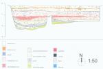
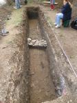
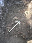
Archaeological excavations should be planned to the west starting from the trench 10, while enhanced archaeological surveillance should be planned from the trench 9. The trench 10 has been fully excavated. Many fragments of pottery (Hellenistic relief cups, late Republican household ceramics and amphorae) were found, as well as several pieces of coins (on conservation). All this indicates that from the 2nd to the 1st century BC there was a settlement in Resnik. In the middle of the trench was a narrow wall that extends in N-S direction. Along the western edge of the trench, and at a depth of 240 cm, a smaller spring appeared. Due to the proximity of the sea it probably mixes with fresh water. The wall was located on the border of two terraces with different heights. The western side is about 2 m deep, and the eastern about 1.30 m deep. On both sides of the wall, at the level of the wall foundation, the concentration of various fragments of ceramics has increased (▼ 1.30 m). There was a bigger concentration in the west, so it can be assumed that this area served as a landfill.
Between trenches 10 and 12, a geo-radar survey was conducted, which showed that the area is rich in architectural remains. Geophysical research was performed by the Geoarheo d.o.o. from Sesvete. On the basis of the survey, the eastern and western borders of the archaeological site Resnik have been determined, while the northern border has yet to be determined by future research (I. Kamenjarin 2006, Hrvatski arheološki godišnjak 2/2005, 356–358).
Director
- Ivanka Kamenjarin
Team
Research Body
- Muzej grada Kaštela
Funding Body
- Agencija Eko-Kaštelanski zaljev


![Download [PDF]](/excavation/skins/fasti/images/results/download_sml.png)


