


Summary (English)
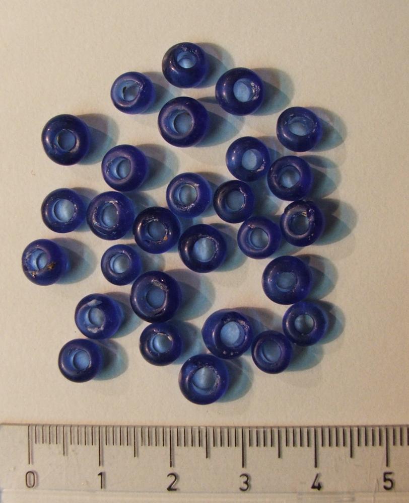
In July 2003, the Museum of Turopolje was notifed by Stjepan Cvetko from Mraclin that earthworks were being carried out at the Rupa site, owned by Milivoj and Mladen Kos. This location is already known on the basis of a field survey of the Turopolje Museum, when the route of the Roman state road Emona – Siscia and several burial mounds in the immediate vicinity of the road were registered. In agreement with the owner of the land, it was decided to archeologically investigate the remains of three burial mounds in which the finds were directly endangered, and funds were provided for their research. The research was conducted in the summer and autumn of 2003. The largest mound, known as burial mound no. 4., was not excavated then. Its excavation was planned for 2005, and was carried out at the end of November and during December. Before the excavation began, four points were geodetically surveyed to obtain a regular 20 m square bounding the circular tumulus. The surface of the tumulus was divided into sixteen sections measuring 5×5 m (a total of 16 squares). Of these ,two 5×5 m squares were opened, for a total of 50 m². These were squares C3 and D3 that descend from the highest point of the tumulus (absolute height 103.66 m above sea level) towards its northern edge. After removing the surface layer of humus and grass, a layer of clay appeared in which several pottery fragments were found. The most important discovery are probably tiny beads of blue glass paste. 28 of them were found at an absolute height of 103.04 m (relative depth approx. 0.6 m) with some soot and a vessel fragment. This was possibly a disturbed incineration grave. This find appeared along the very edge of the excavated squares, so it is not excluded that the rest of the beads (which were probably strung in a necklace) are located in adjacent squares C2 and D2, which were not explored that year.
Along the southern corner of square C3, a possible foundation of a broken brick wall (SJ 4) about thirty centimetres wide was found (at an abs. height of 102.72 m), which extends in the northeast-southwest direction. It continues into the unexcavated square B3, so only later research will reveal the exact role of this building structure. The lowest point of the excavated squares is 102.61 m. At the highest point of the tumulus, the relative height of the excavated square is about 1 m, and at its lowest part about 70 cm. Although there is no confirmation of this in the findings so far, this mound was certainly used for burial, as well as three grave mounds excavated in 2003 not far from it. It can be dated to the same period as the already excavated burial mounds, i.e. in 1st – 2st century. The excavation of burial mound 4 is the continuation of the research from 2003, when three smaller tumuli were excavated in the immediate vicinity, about 200 m to the west. This group of tumuli was located along the former Roman road that connected Ljubljana (ancient Emona) and Sisak (Siscia). Three previously excavated burial mounds provided data on the burial rites of the local population who found themselves under the influence of Roman culture and way of life in the 1st and 2nd centuries AD (L. Čataj, I. Knezović, T. Pintarić 2006, Hrvatski arheološki godišnjak 2/2005, 152–153).
- Lea Čataj
- Ivan Knezović
- Tatjana Pintarić
Director
- Ivan Knezović
Team
- Lea Čataj
- Vesna Zmaić
Research Body
- Muzej Turopolja
Funding Body
- Grad Velika Gorica
- Ministarstvo kulture Republike Hrvatske
- Zagrebačka županija
![[PDF]](download.php?file=11775.jpg "Download")