


Summary (English)
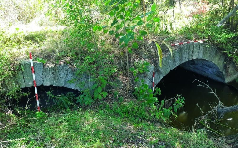
EXPLORATIONS NEAR THE VILLAGE OF KONUSH (Chavdar Kirilov – kirilovarch@gmail.com) The settlement was located based on historical sources, maps and satellite imagery. It was founded in the period 1400 – 1430 when Tatars who were colonists from Asia Minor settled there, led by Minnet Bey. His son, Minnetoglu Mehmed Bey participated in the Ottoman conquest of the Western Balkans during 1450 – 1475 and was consecutively appointed Sanjak-bey of Smederevo and Bosnia. He built a residence, a mosque, a karavansaray and baths in Konush, and settled Christians from Bosnia there. During the first half of the 16th century, four satellite settlements appeared around the residence: two Christian and two Muslim, while a waqf was established for the maintenance of the residence. Konush was situated on the main road from Belgrade to Constantinople and from the 1530s to c. 1580s, a number of West European travelers and diplomats passed through the village or stayed there and they described the settlement. From the 1580s onwards, Konush disappeared from the itineraries, since the main road was moved to the north. The settlement remained a nahiye in Filibe kaza. Subsequently, it was divided in two villages: a Christian one called Bulgarsko Konush (Bulgarian Konush) and a Muslim one called Tursko Konush (Turkish Konush). In 2019, a geomagnetic survey was performed on an area of 38,000 sq. m and field surveys were carried out on an area of 60,000 sq. m. In addition, a tachymetric mapping of the surveyed area was done. The geomagnetic mapping showed the western end of the settlement and several areas with concentrations of anomalies within the settlement, indicating the existence of large buildings (stones, building ceramics and window glass were found there as well). There were numerous anomalies indicating the existence of small structures everywhere on the surveyed area of the site. Fragments from tobacco pipes and from filjan for coffee were concentrated along the periphery of the supposed central square. Flints from threshing-boards, pieces of slag, iron bars and melts were discovered mostly in the periphery of the settlement. The finds inside the settlement included mostly pottery of the 15th – 18th centuries, including pottery produced in Demotika and Çanakkale, fragments from porcelain vessels, glass bracelets, fragments from glass windows and glass vessels. A bridge of the Ottoman period was documented to the north of the village; it was built over Konushka Reka River and belonged to the infrastructure of the main road from Belgrade to Constantinople. The bridge was probably supported by three arches and was 3.70 m wide and probably more than 10 m long.
- Chavdar Kirilov - Department of Archaeology, Sofia University St. Kliment Ohridski
Director
- Chavdar Kirilov - Department of Archaeology, Sofia University St. Kliment Ohridski
Team
Research Body
- Sofia University St. Kliment Ohridski
![[PDF]](download.php?file=13442.jpg "Download")
![[PDF]](download.php?file=13443.jpg "Download")