Summary (English)
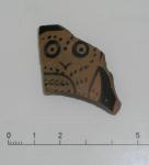
Apart from the trench on the southern slope of Salamandrija, where many finds from the Bronze, Greek and early Roman ages are known, exploration was concentrated on the plateau, where according to the findings so far, the existence of a late antique fort has been assumed. On the southern slope, the excavations in the V-6 quadrant continued. Ten fragments with graffiti (mostly with one letter each) were found, as well as several beautiful fragments of Athenian red-figure vessels. The finds of prehistoric pottery belong to the so-called Cetina culture of the late Eneolithic and early Bronze Age.
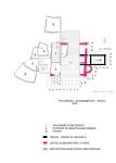
Excavations revealed the remains of the northern wall and north-eastern corner of the fort. The outlines of the entire eastern wall of the fort are about 19 m long. Approximately 7 m to the north is located a present-day cistern, it is very possible that it was vaulted and that it was also a cistern in the Roman fortress. The vault collapsed over time, as did the northern wall.
In the backfill of the pit (s.j. 6120) the beak of a clay lamp without traces of glaze was discovered, it belongs to early medieval lamps of southern Italian production in the 9th – 14th c. Since most of the lamp is missing, a more precise dating is difficult, along with the earlier find of the Roman III. Argira (1028-1034) gold coin, are so far the oldest known medieval finds on Palagruža.
Ground-penetrating radar measurements showed that architectural remains can be expected in several places under the pavement of the rainwater collector. In the southern half of the pavement, radar showed some structures that indicated walls placed diagonally in relation to the walls of the fort or the church. Anticipating that architectural remains from the time before the construction of the fort could be found there, quadrants U-13 and 14 were opened. Inside quadrant U-13, a part of the construction, slightly semi-circular in shape, was found, preserved in two rows of stone bound with hydraulic mortar. It seems that the structure was a support or foundation for some kind of wooden beam that stood there, because its imprint was found in the mortar. It turned out, however, that the structures shown by the radar is only a slightly elevated bedrock.
By carefully cleaning the surface in front and behind the front wall of the church of St. Michael, it was determined that this part was built over a pit carved into the bedrock. The pit (about 1.20 m deep, about 2 m diameter) was filled with rubble with several fragments of Late Antique pottery. During the excavation in the foundations of the front wall of the church, a fragment of a porcelain plate with a “stamped” scene of an oriental landscape was discovered, which was made in England (Primavesi & Sons) after 1860 – terminus ante quem non of the construction of the church. This certainly shows that the church was built either immediately before the lighthouse (1876) or during its construction (Branko Kirigin, Tea Katunarić, Maja Miše 2006, Hrvatski arheološki godišnjak 2/2005, 383–386).
- Branko Kirigin
- Tea Katunarić
- Maja Miše
Director
- Branko Kirigin
Team
Research Body
- Arheološki muzej u Splitu
Funding Body
- Ministarstvo znanosti, obrazovanja i športa Republike Hrvatske


![Download [PDF]](/excavation/skins/fasti/images/results/download_sml.png)
