


Summary (English)
The suitability of the layout of Avenida del Lago, the road that connects Mérida and the Proserpina Reservoir, located in Area V of general protection according to the Special Plan for the Protection of the Archaeological Ensemble of Mérida, motivated archaeological interventions to assess the impact of the projected work, since the existence of archaeological sites of interest was already known.
This area is located to the NW of Augusta Emerita, outside the city walls, in a valley between several gently sloping hills with soils used mainly for pasture. In the immediate surroundings, several archaeological remains have been previously found which are directly or indirectly associated with the Roman city: the layout of the Proserpina Roman conduit, remains of a lime kiln and many rectangular rooms arranged in a row which probably belonged to the pars rustica of an Early Roman Empire rural settlement.
The layout of the current road partially fossilizes a secondary road identified as a via privata, located about 80 m from the Iter ab Emerita Caesaraugustam. The earliest phase of the road is represented by SU 7, where ceramic fragments dating between the second half of the 2nd century A.D. to the early 5th century A.D. have been documented. The road continues being used during the Late Antiquity and even during the Middle Ages.
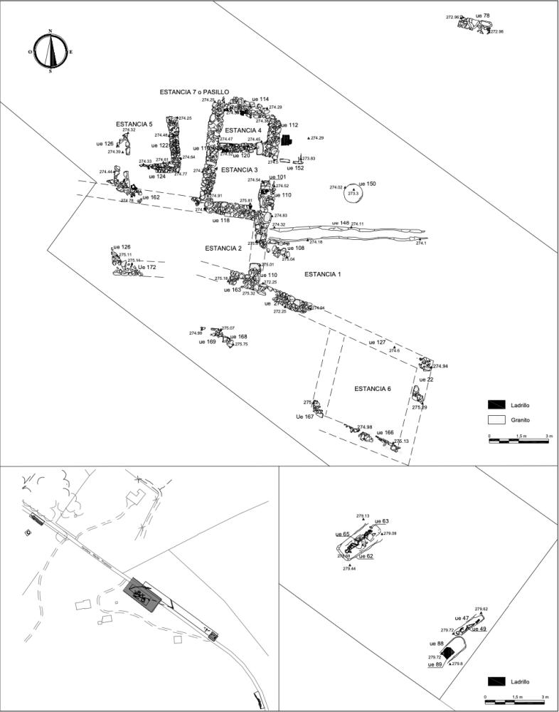
The area of intervention was divided in 3 different zones determined by the design of the new route and by the remains previously documented in the works. A possible villa, equipped with an advanced network of channels, was identified in Zone I and II. We could estimate that it dates to the Early Roman Empire and was used at least until the 4th century A.D., as shown by the ceramic materials documented in the deposits that covered the remains.
From then on, the villa seems to be abandoned, a new area of occupation appeared on the east end of Zone II with domestic and agricultural buildings, around which a series of burials were documented, forming a funerary area whose main axis must have been the documented road. The absence of grave goods in all the burials is notable. The interpretation of this Late Antiquity rural necropolis is not clear. In that period, burial sites were commonly associated with basilica-type meeting places, which were usually villae reused and transformed for these functions. However, the remains documented in this intervention are too scarce to confirm this connection. There is also the possibility that this type of funerary area was arranged around roads or important communication routes, as in this case, where the Roman road connected Emerita with the Proserpina Reservoir.
From the Early Medieval Period, a new agricultural building was identified in the archaeological stratigraphy, located on the promontory occupied by the Early Imperial villa. The partial excavation of this construction has allowed us to identify the floor plans of different rooms, some of which are detached and, in general, difficult to interpret due to their alteration by anthropic activities and the heavy erosion suffered. Few remains of rough masonry walls have been preserved.
Several Early Medieval burials were documented in Zone II, possibly related to this rural housing context. Everything seems to indicate that in the Emirate Period this area continued to be an important road reference point.
Finally, in the Contemporary Period, the development of a new road and the installation of new channels to supply the rural dwellings the area have had a negative impact on the preservation of the remains.
(translation by Himar González González)
- Nuria Sánchez Capote
Director
- Nuria Sánchez Capote
Team
- Félix Aparicio
- Fco. Javier Pacheco
- Peones especializados: Manuel Suárez, Alfredo Sánchez, Antonio Sánchez, José María Caballero
Research Body
- Consorcio Ciudad Monumental de Mérida
Funding Body
- GÉVORA S.A.

![[PDF]](download.php?file=14542.jpg "Download")

![[PDF]](download.php?file=14543.jpg "Download")

![[PDF]](download.php?file=14544.jpg "Download")
![[PDF]](download.php?file=14545.jpg "Download")

![[PDF]](download.php?file=14546.jpg "Download")

![[PDF]](download.php?file=14547.jpg "Download")

![[PDF]](download.php?file=14548.jpg "Download")