


Summary (English)
The team from the Radboud Universiteit Nijmegen (Netherlands) dug two trenches and surveyed a stretch of the via Appia Antica at the height of the Villa dei Quintili (V mile). The work was a follows:
1) Trench put in between the two tumuli, the so-called tombs of the Orazii, dug in order to establish their exact perimeter and chronology and to collect other related data
2) Trench positioned inside a Republican wall built of squared tufa blocks, part of the so-called Republican ustrinum
3) Inventory of the archaeological remains situated in the sector in question
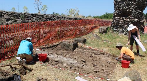
4) 3D reconstruction from digital photographsIn 2010, surface cleaning had taken place including the removal of a layer of asphalt partially covering the area. A 12 × 4 m trench was opened, which at first exposed an illegal dump of modern rubble. Below this, part of the opus caementicium base was exposed along both tumuli. Between the tumuli was a small opus reticulatum wall, probably late Republican, which may have been the dividing wall between the tombs or part of an unidentified structure. Large stone blocks were also present, perhaps from the perimeter walls of the tumuli. The pottery and other finds indicated a 1st century B.C. or 1st century A.D. date. There were no finds from between the late antique period and the 1900s.
Directly below the modern ground surface, to the east of the wall, were the remains of a columbarium, which appeared to abut the older wall. The upper part of a series of jar embedded in mortar forming a counter structure was exposed. Further excavation is necessary to establish its precise nature and chronology. The finds from the upper layer gave a 2nd century A.D. date.
On the west side, the soil seemed to be sterile apart from some fragments from marble blocks, only a few of which with decorative elements such as dentils, and statue parts. This was clearly material collected and broken up for use in a limekiln. Below these blocks, heaped together with stones and pieces of basalt, was a layer of ash and pottery of imperial date.
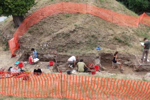
Another columbarium was situated to the north of the wall, part of its opus spicatum floor and a threshold on the west side, visible on the surface by the wall separating the public land from the private properties. The columbarium may have been formed by two adjoining chambers. As with the other, due to the mass of material covering it, excavation of the first layer remains to be completed.
The inventory continued the work of 2009 and 2010, mapping the monuments using DGPS, photographs and drawings. The aim is to produce an archaeological map of the area, which could be used as the basis for a more detailed analysis of this stretch of the Via Appia in the Roman suburb.
Three-dimensional documentation was made of some monuments, which can be inserted into the GIS system and could be used for scientific and educational purposes.
- Stephan T.A.M. Mols - Radboud University Nijmegen
- Christel Veen - Radboud University Nijmegen
- Jeremia Pelgrom - Radboud University Nijmegen
- Eric Moormann - Radboud University Nijmegen
Director
Team
Research Body
- Radboud University Nijmegen
Funding Body
- Reale Istituto Olandese a Roma
![[PDF]](download.php?file=67.jpg "Download")
![[PDF]](download.php?file=68.jpg "Download")