


Summary (English)
This year’s investigations undertaken by the Radboud Universiteit Nijmegen (The Netherlands) extended both excavation areas and continued the survey begun in 2011 along the Via Appia at the height of the Villa dei Quintili (V mile). The following work was completed:
1) Excavation between and behind the two tumuli known as the tombs of the Orazii, in order to establish the precise perimeter and chronology of the northern tumulus and extent of the restoration carried out by Luigi Canina in the 19th century.
2) Excavation around the Republican wall built of regular tufa blocks.
3) Inventory of the archaeological remains present on the stretch of road under investigation
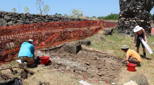
4) 3D reconstruction made from digital photographs.Two trenches were put in at the northern tumulus, so-called “degli Orazi” (1). In the first, the opus caementicum base found in 2011 was followed. The perimeter of the tumulus was seen to be much smaller than it appears. The second trench was put in to the west of this tumulus that is to the rear with respect to its position on the Via Appia. Here, a curvilinear structure was exposed which may have been part of the tomb’s entrance, together with the inhumation of a male juvenile dated by a coin of Antoninus Pius to the second half of the 2nd century A.D. or later (fig. 1). The pottery and other finds indicated that the first construction phase dated to the 1st century B.C. or 1st century A.D. and that it was in use until the 2nd century A.D. There were no finds for the period between the late antique and the 20th century.
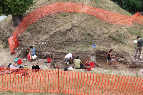
The trenches, begun in 2011, on either side of the Republican wall built of tufa blocks on a north-south alignment were deepened (2). The wall’s continuation, both to the north and south, was exposed. Before the northern continuation of the wall, excavation of the colombarium discovered in 2011 continued. Several levels corresponding with various building phases were identified, which the pottery and tile/brick stamps date to the 2nd century A.D.
The inventory (3) continued the work of those undertaken 2009 and 2011 and consisted of mapping the monuments with DGPS, photographic and graphic documentation. The primary aim is the creation of an archaeological map of the area that may be used as a base for a more detailed analysis of this stretch of the Via Appia in the suburbium of Rome.
A grant from the Netherlands Organization for Scientific Research meant work continued from October 2012 on a survey of the areas adjacent to this stretch of the Via Appia, which is being carried out by a team from the Dutch Institute in Rome. The Università Libera of Amsterdam undertook geophysical investigations. Other partners in the project are the Soprintendenza Speciale per i Beni Archeologici di Roma and the German Istitute of Archaeology in Rome. The project’s name is “Mapping the Via Appia”.
- Christel Veen - Radboud University Nijmegen
- Stephan T.A.M. Mols - Radboud University Nijmegen
- Eric Moormann - Radboud University Nijmegen
Director
Team
- Jeremia Pelgrom - Radboud University Nijmegen
Research Body
- Radboud Università di Nimega
Funding Body
- Netherlands Organisation for Scientific Research NWO
- Reale Istituto Olandese a Roma
![[PDF]](download.php?file=282.jpg "Download")
![[PDF]](download.php?file=283.jpg "Download")