


Summary (English)
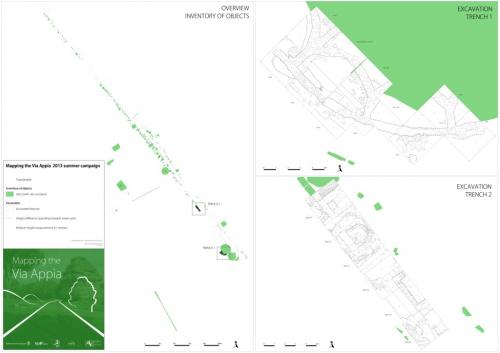
Excavators from Radboud Universiteit Nijmegen (Netherlands) enlarged both trenches and continued the surface survey begun in 2011 and 2012 along a stretch of the via Appia next to the Villa dei Quintili (V mile). The following work was carried out:
1) A trench was dug behind the two tumuli known as the tombs of the Horatii, in order to establish the exact perimeter and chronology of the northern tumulus and of the restoration undertaken by Luigi Canina in the 1800s;
2) A trench was put in around the so-called ‘Republican’ wall made up of regular tufa blocks;
3) An inventory was made of the finds recovered;
4) A 3D reconstruction based on digital photographs was created.
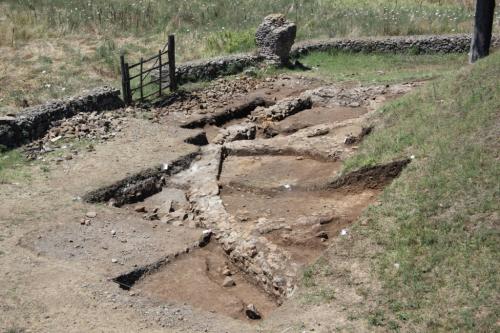
A large trench was dug behind the north tumulus of the Horatii, on the right side with respect to its position on the via Appia (1). Here, in 2012, a curvilinear structure was exposed that was difficult to interpret. In 2013, this trench was extended to the north, west and south, partly on the basis of the results of a georadar survey undertaken by the team from the British School at Rome. The excavation revealed the perimeter wall to the west of the original tumulus with small semicircular wall inside it. The position further east of the present tumulus with respect to the newly discovered perimeter wall seemed to indicate that the monument was reconstructed by Luigi Canina in the 1800s in a position that was closer to the via Appia than it had been originally. The pottery and other finds indicate a date for the first construction phase in the 1st century B.C. or 1st century A.D. and use until the 2nd century A.D. There were no finds relating to the period between the late antique to the 1900s.Work continued in the trench (2) on both sides of the N-S tufa block Republican wall (opened in 2011). Excavation continued of the columbarium found in 2011 and several levels corresponding with various building phases were exposed. These were dated by the pottery and brick/tile stamps to the 2nd century A.D. The other columbarium situated in front of the tufa block wall contained funerary jars with the remains of cremated bones, a small jug and three lamps, almost all intact. A bronze As of Domitian in the lowest level gives a terminus post quem of 81 A.D.
The inventory (3) continued the work undertaken in 2009 and 2012 and consisted of the mapping of the monuments using DGPS, photography and drawing. The main aim is the creation of an archaeological map of the area under examination that will provide the base for a more detailed analysis of this stretch of the via Appia in the suburbium of Rome.
For the first time, some of the monuments were recorded in 3D (4). These will be inserted into the GPS system and may provide the base of both a scientific and popular view of the via Appia.
- Eric Moormann - Radboud University Nijmegen
- Christel Veen - Radboud University Nijmegen
- Stephan Mols - Radboud University Nijmegen
Director
- Stephan T.A.M. Mols - Radboud University Nijmegen
Team
- Jeremia Pelgrom - Radboud University Nijmegen
Research Body
- Radboud University Nijmegen
- Reale Istituto Olandese a Roma
Funding Body
- Netherlands Organization for Scientific Research
- Radboud University Nijmegen
- Reale Istituto Olandese a Roma
![[PDF]](download.php?file=720.jpg "Download")
![[PDF]](download.php?file=736.jpg "Download")