Summary (English)
In 2007, the protected archaeological area of the site of Buoncammino was damaged by the laying of water pipes, an intervention arbitrarily decided by the town council of Santa Teresa di Gallura. An archaeological investigation was ordered by the Superintendency to assess the damage caused by this activity.
The damage to the archaeological remains occurred along the western side of the road in front of the facade of the modern church of Buoncammino where, a mechanical digger had been used to cut a trench c. 80 m long, 60-120 cm wide, and 100-120 cm deep, which cut across a long, NW-SE, wall at three points.
In order to assess the nature of the damage, two trenches were dug, A and B, in correspondence with the two worst cuts. It was seen that both presented a stratigraphy belonging to the same context and it was decided to concentrate on trench A, extending it to the east as far as incorporating a sector of the archaeological area characterised by a rise in the terrain. This choice resulted in the discovery of more evidence that furthered knowledge of the site. In fact, the eastward extension of trench A, although of limited size (18 × 6 m) revealed several periods of occupation: Roman (1st-5th century A.D.), medieval (13th-15th century), and modern (end of the 18th-first half of the 19th century).
The medieval phase was constituted by 13th-15th century materials (pottery and metal artefacts) overlying the levels relating to the abandonment of the Roman structures. It appeared that this area was used as a rubbish dump in the Middle Ages.
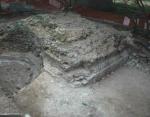
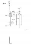
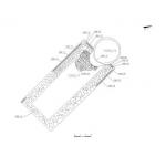
As regards the Roman period, the excavation revealed the presence of a complex of buildings with a central nucleus, formed by a sort of rectangular podium with an apsidal termination on the NW front with a rock-cut basin. This structure, denominated 1000/1, seemed to stand at the centre of an open space (1000/2), in turn bordered by other rooms (1000/3).
In synthesis, although only a limited area has been investigated, the excavations undertaken in 1981, 1991, and between 2007 and 2008 have revealed a substantial stratigraphic sequence with phases dating to between the Roman and modern periods. This archaeological area merits further investigation, not only to add to knowledge of local history, but also, and perhaps more importantly, in relation to the much debated location of Tibula. Traditionally thought to lie within the territory of Santa Teresa, and only recently indicated as being near Castelsardo, this is a very important chapter in the study of the Romanisation of Sardinia.
- Domingo Dettori
- Angela Antona
Director
- Angela Antona - Soprintendenza per i Beni Archeologici delle Province di Sassari e Nuoro
Team
Research Body
- Soprintendenza per i Beni Archeologici per le province di Sassari e Nuoro
Funding Body
- Fondi pubblici (Comune di S. Teresa Gallura)


![Download [PDF]](/excavation/skins/fasti/images/results/download_sml.png)


