
Summary
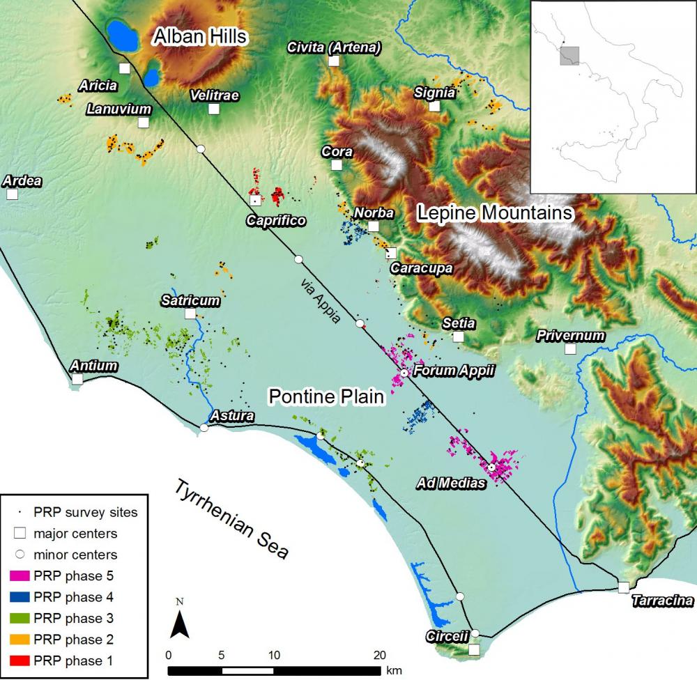
- The Pontine Region Project (PRP) is an on-going Dutch landscape archaeological project in the Pontine region, situated c. 60 km south of Rome in Lazio, Central Italy. It started in the late 1980s as a side project to the Dutch excavations at Satricum, but soon developed into an independent research project under the direction of Attema. The project combines archaeological field surveys, geophysical prospections, geo-archaeological investigations and targeted excavations to study the long-term history of settlement and landscape in the Pontine region, with a particular focus on processes of centralisation in the late Iron Age and Archaic period, the impact of Roman colonisation in the Republican period, and the functioning of regional systems of production and exchange in the Roman period. The project has gone through several phases in which different landscape zones (Lepine uplands, interior plain, coastal areas as well as the adjacent Alban Hills and Sacco valley) were targeted. Recent research conducted within the PRP includes the investigation of the Roman roadside settlements of Forum Appii and Ad Medias (as part of the Minor Centres Project) and the Avellino project, which aims to investigate the impact of the Bronze Age eruption of the Vesuvius on settlement and landscape. ............................................................................................................................. Please cite this Record as: Haas, TCA de, Leusen, PM van, Attema, PAJ, Tol, GW. The Pontine Region Project [data-set]. Fasti Online Survey [distributor]. Permalink: http://www.fastionline.org/survey/site/AIAC_454
Project Dates
- 1987 - present
Periods
- No period data has been added yet
- 10500 BC
- 8000 BC
- 1000 BC
Survey Method
![[ed]](/survey/skins/fastisur/images/plusminus/edit.png "Edit")
![[view]](/survey/skins/fastisur/images/plusminus/view.png "View")
- The PRP dataset was gradually built up in phases, each lasting a funding cycle (typically, four or five years). In each of these phases, one or more physiographical or cultural units was targeted with a specific set of questions in mind. With the advent of user-friendly databases and, later, mobile GIS applications, field and data processing procedures became more standardized and efficient. This contributed to an intensification of field walking and collection strategies. While intensive off-site approaches were used from the start, the object of study (sites or off-site patterns), the intensity of field walking, and the sampling methods were adapted to the specific and changing research questions of individual project phases. ............................................................................................................................. Data archives are available for some phases of the project: Phase 2 (Sezze, Segni and Albano/Lanuvium survey): https://easy.dans.knaw.nl/ui/datasets/id/easy-dataset:33011 The Minor Centres Project: https://easy.dans.knaw.nl/ui/datasets/id/easy-dataset:67156 The Hidden Landscapes Project: https://easy.dans.knaw.nl/ui/datasets/id/easy-dataset:68473
Research Focus
Other Comments
- Research Directors: Prof. dr. Peter Attema (Groningen University); Dr. Martijn van Leusen (Groningen University); Dr. Tymon de Haas (Leiden University); Dr. Gijs Tol (University of Melbourne). Field Directors: Dr. Tymon de Haas (Leiden University); Dr. Gijs Tol (University of Melbourne); Dr. Luca Alessandri (Groningen University). Other Team members: Prof. dr. Jan Sevink(University of Amsterdam): palaeogeographic research; Dr. Barbara Borgers (University of Vienna): ceramic studies; Mrs. Filmo Verhagen (Uppsala University): ceramic studies; Dr. Mans Schepers (Groningen University): paleoecological research.
- -long-term regional developments in settlement, landscape and land use -the impact of urbanization on settlement and landscape -the impact of early Roman expansion on settlement and landscape -the reconstruction of regional patterns of production and exchange
Funding Body
- University of Groningen; Netherlands Organisation for Scientific Research; Royal Dutch Academy of Sciences; Regione Lazio; Leids Universiteits Fonds; University of Melbourne
Research Institution
- Groningen Institute of Archaeology; Leiden University; University of Melbourne (partners at various institutions)
Director
-
Director
- Prof. dr. Peter Attema
- Martijn van Leusen - Groningen Institute of Archaeology
- Tymon de Haas
- Dr. Gijs Tol, University of Melbourne
![[PDF]](/survey/skins/fastisur/images/results/download_sml.png "Download")
